


I thought I knew Costa Rica’s Pacific coast before I ever saw it. In my head it was one long strip of palm-fringed sand with consistent sunshine, easy driving and similar beach towns repeating down the map. Then I spent 16 days traveling overland from the dry north near Tamarindo to the wild southern corner around the Osa Peninsula, using a mix of rental car and local shuttles, staying in everything from an all-inclusive in Guanacaste to a jungle cabina reached by a muddy track. I arrived on the Pacific first in Playa Hermosa, Guanacaste, then continued south through the Central Pacific around Manuel Antonio and Dominical, before ending in the South Pacific near Sierpe and Drake Bay. The further I went, the more that neat mental picture fell apart, replaced by very different coasts in climate, vegetation, wildlife and even the way travel works day to day.
How the Journey Unfolded: One Coast, Several Worlds
My starting point was Liberia, the main airport for Costa Rica’s northwest. I picked up a small SUV at the airport desk and in under an hour was checking into a mid-range hotel above Playa Hermosa in Guanacaste. The road was paved and straightforward, fuel was easy to find and the sky was a hard blue with barely a cloud. Over the next five days I based myself first in Playa Hermosa and then near Tamarindo, using the car to hop between beaches like Conchal, Flamingo and Avellanas. It felt like the accessible, resort-oriented Pacific I had imagined, right down to the sunset cocktails and beach clubs.
From there I drove south past Nicoya and Puntarenas, then joined Route 34, the Costanera Sur, which now carries most traffic along the central and southern Pacific seaboard. Sections of this highway are broad and modern, but construction zones and slow trucks quickly taught me to treat official driving times as optimistic. A Google estimate of four hours from Tamarindo to Manuel Antonio turned into a six-hour slog with a stop for rain and roadworks around the Río Coronado, where a provisional bridge has been diverting vehicles while a new structure is built. By the time I rolled into Quepos, the humidity felt heavier, the hills greener and the surf rougher than up north.
The last section of the trip was a leap into wilder territory. I left the rental car in Uvita to avoid the rougher roads beyond and joined a shared shuttle to Sierpe, followed by a boat ride downriver to Drake Bay at the northern edge of the Osa Peninsula. In this South Pacific zone annual rainfall is significantly higher than around Tamarindo and even Manuel Antonio, and the transition is obvious in the sheer density of rainforest spilling down to the shore. Here my days revolved less around beach-hopping and more around the logistics of tides, boat schedules and national park entry rules for Corcovado.
By the end of the journey, what surprised me most was not simply that the Pacific gets wetter toward the southeast, which climate maps make clear, but the way that change plays out in daily travel realities. Road access, hotel design, meal times, wildlife noise at night and even the color of the sand all shifted. The Pacific coast is not one destination; it is at least three, and trying to treat Guanacaste, the Central Pacific and the South Pacific as a single interchangeable strip of beach was the first mistake I made.
Dry North: Pale Sand, Easy Roads and a False Sense of Sameness
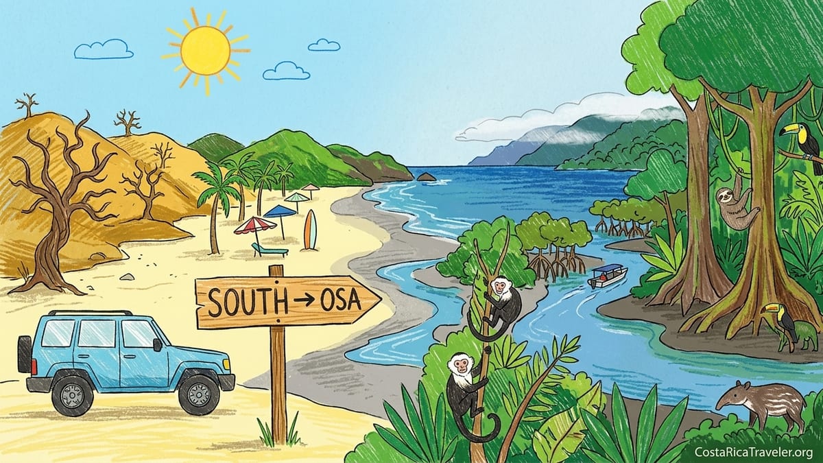
In the north Pacific, particularly the Guanacaste region around Playa Hermosa and Tamarindo, the landscape in the dry season feels closer to savanna than jungle. Trees stand bare and twisted, the hills are golden-brown and the beaches are broad, often with pale or honey-colored sand that feels powdery underfoot. In March, daytime highs regularly push past 33 degrees Celsius, but the humidity is relatively moderate compared to further south. Skies are frequently cloudless, giving the sunsets a clean gradient from orange to deep purple, with very little haze.
Beaches here are well set up for casual visitors. At Tamarindo and Playa Flamingo, surf schools line the sand, rental boards are stacked in rows and vendors drift past selling coconuts and handmade jewelry. Swimming is feasible at many bays, though the open Pacific means there can be rips on exposed stretches. Lifeguard coverage is improving but still patchy, so local advice remains essential before wading in. Cafes and restaurants extend right to the edge of the sand, serving everything from ceviche and casados to imported craft beer. Prices cater to a mix of North American and European tourists, and posted menus in English are the norm.
Driving between northern beaches is remarkably simple compared to other parts of the country. Paved secondary roads link Liberia to Hermosa, Coco and Tamarindo, and even gravel spurs toward more low-key spots like Avellanas and Junquillal are manageable in a small SUV outside the wettest months. Fuel is available in every main town, and distances are short. It is realistic to visit two or three beaches in a single day, which feeds the illusion that the whole Pacific can be sampled in the same hop-and-go way.
That convenience is part of what gave me a false impression. With so many beaches within an hour or two, it was easy to see the coast as a series of similar options differentiated mainly by crowd level and nightlife. Wildlife sightings did happen, but mostly as background: iguanas on the hotel path, a few howler monkeys in the distance, pelicans cruising the surf line. I assumed that further south would mean more of the same with a slightly greener backdrop. In reality, the Central Pacific already changes the script.
Central Pacific: Greener Hills, Shorter Beaches and Heavier Air
Heading south from the Nicoya Peninsula toward Jacó and Manuel Antonio, the hills grow steeper and closer to the water. By late April the slopes around the Central Pacific are already noticeably greener than Guanacaste’s plains, and by June the landscape is vivid. The climate here is still governed by a pronounced dry season from around December to March, but average annual rainfall is higher than in the north, and the humidity feels heavier even on sunny days. Brief but intense afternoon downpours are common once the wet season settles in.
The beaches change character too. Around Jacó the sand darkens to a charcoal-grey mix of volcanic grains, which can get uncomfortably hot under the midday sun. Surf conditions tend to be punchier, with consistent breaks that attract intermediate and advanced surfers but can be intimidating for casual swimmers. In Manuel Antonio itself, small coves like Playa Espadilla and Playa Biesanz offer more protected water, but even here rip currents can appear without much warning. On my second day I watched a family encouraged by the calm surface step into a channel that quickly deepened; a lifeguard’s whistle sent them back before anything serious happened, but it was a reminder that “gentle-looking” does not always equal safe.
Development in the Central Pacific feels denser than in Guanacaste, but more vertical and compressed. Quepos and Jacó both have strips of mid-rise hotels and condominiums, supermarkets, pharmacies and a busy mix of local and foreign-owned restaurants. In Manuel Antonio many hotels cling to the ridge road above the coast, which can mean gorgeous sunset views but also steep walks or short taxi rides down to the sand. I made the mistake here of choosing a boutique hotel with a wonderful forest outlook but no sidewalk-friendly access. The five-minute drive to the beach translated into a sweaty 45-minute walk up and down a narrow, winding road whenever I tried to go on foot.
One of the most noticeable shifts from the north is how central wildlife becomes around Manuel Antonio. The national park, which now requires advance reservations and enforces daily capacity limits, packs a dense range of animals into a small area. Within an hour of entering the park with a local guide I had seen white-faced capuchin monkeys, sloths, agoutis and bright red land crabs. Even outside the official boundaries, it is common to find squirrel monkeys moving through hotel gardens and scarlet macaws shrieking overhead at breakfast. In other words, this part of the Pacific begins to feel like rainforest coast, even though the surrounding towns are busy and highly developed.
South Pacific: When the Rainforest Finally Reaches the Sea
The real pivot point of the journey came further down the map, once I passed Dominical and Uvita and headed toward the Osa Peninsula. South of the Barú River the highway continues as Route 34, but the atmosphere shifts. The forest grows thicker, rivers cross under the road more frequently and cloud banks hang over the coastal mountains even on days that begin in sunshine. Climatological data for the South Pacific region shows some of the highest annual rainfall totals in Costa Rica, and the difference is visible in the sheer lushness of the vegetation.
Here the sand is often darker and coarser, backed not by rows of hotels but by curtains of primary and secondary forest. At low tide vast stretches of beach open up, but the waves can pound, forming heavy shore breaks that discourage casual swimming. Locals and guides were much more cautious about recommending specific swim spots, often steering visitors toward river mouths or small bays at particular tide levels rather than suggesting that any part of the beach was appropriate at any time. On more than one occasion I walked half an hour along a dramatic, empty shoreline without seeing another person in the water.
Road access, so straightforward in Guanacaste, becomes part of the adventure in the South Pacific. While Route 34 itself is paved, many feeder roads toward smaller coastal villages or trailheads are gravel or dirt, and some involve river crossings that are only advisable in the dry months or in a high-clearance vehicle. This is where I paid for my earlier assumption that I could “see everything” in two weeks. I had marked both the Osa Peninsula and smaller inland waterfalls on my map, but underestimated how much time slow, winding roads would add. The result was a rushed day trip where I spent more hours in the car than on the trails, and had to skip a planned stop in Puerto Jiménez entirely.
In Drake Bay and along the Sierpe River, rainforest and wildlife finally eclipse the beach as the main draw. I traded long walks along the sand for early-morning boat rides into mangrove channels and full-day hikes into Corcovado National Park, which continues to limit visitor numbers and requires permits bought through registered operators. Sloths, howler monkeys and toucans gave way to tapir tracks, spider monkeys and the possibility of seeing wild cats. The soundtrack of the coast changed too, from surf and bar music in Tamarindo to cicadas, frogs and distant waves thudding against the shore below the jungle.
What Actually Changes as You Travel Down the Pacific Coast
Several patterns emerged as I moved south that are useful for planning. The first is the strength of the dry and wet seasons. All along the Pacific there is a marked dry stretch that typically runs from about December through March or April, followed by a rainy period from May into November. However, Guanacaste in the north has the most extreme dry season, with many hillsides turning brown and dusty and some smaller rivers shrinking or disappearing altogether, while the South Pacific remains visibly humid and green even in March and April. By the time the wet season deepens in September and October, the far south can experience very frequent heavy rains, while the north may still see more breaks of sunshine.
The second change is in daily humidity and heat index. Air temperatures may not differ dramatically between Hermosa and Drake Bay, but the combination of higher rainfall and thick forest cover in the South Pacific makes the air feel heavier and often a few degrees warmer at night. In practical terms, this affects how comfortable certain types of accommodation are. In Guanacaste I slept easily with a ceiling fan and open windows, while in the Osa a simple fan was not always enough to cut the humidity. For budget travelers who prefer non-air-conditioned lodges, this is worth factoring in.
Crowds and development patterns evolve as well. The north features clusters of large resorts, all-inclusives and beach towns where English is widely spoken and services such as surf schools, yoga studios and international restaurants are dense. The Central Pacific has busy hubs like Jacó and Quepos but mixes them with quieter pockets and hilltop boutique hotels. In the South Pacific, especially around Drake Bay and Carate, built-up areas thin out considerably and many lodges are reached only by boat or rough track. That does not mean they are empty; popular wildlife lodges often book out months in advance, particularly in the driest weeks, but the feel of the place is remote rather than urban-beachy.
Finally, the balance between beach time and rainforest time shifts. In Guanacaste and much of the Central Pacific, my days revolved around which beach to visit, whether to surf or swim and where to be for sunset. Forest walks and wildlife tours slotted in as optional excursions. In the South Pacific, the situation reversed. I timed my days around national park entry slots, boat departures, river levels and weather windows for hiking, with the beach often serving merely as the edge of the forest rather than the main playground.
Mistakes, Lessons and How to Plan a Smarter Route
The most instructive mistakes I made came directly from underestimating the differences between these regions. The first was trying to cover too much coastline in a limited timeframe. On paper, a journey from Liberia to the Osa Peninsula looks straightforward, linked mostly by a single primary highway. In reality, traffic around San José exits, intermittent construction along Route 34 and slower coastal stretches add hours. Attempting to squeeze Tamarindo, Manuel Antonio, Uvita and Drake Bay into ten days would have meant spending half the trip in transit; even with sixteen days I felt pressed for time in the south.
The second mistake was assuming that every beach would be suitable for relaxed swimming. In Guanacaste, I often waded in after a quick scan for obvious rips, and apart from a few rougher days the experience was forgiving. Once I reached the Central and South Pacific, conditions varied more sharply by tide and local topography. I saw more red flags and warning signs, more rocky entries hidden at high tide and more heavy shore breaks. Asking local guides and paying attention to where Costa Rican families chose to swim became non-negotiable habits, and there were entire days in the Osa when I skipped the ocean entirely in favor of river pools and guided hikes.
Hotel location was another learning point. In Tamarindo and Hermosa it is easy to stay directly on the beach and still be within short walking distance of shops and restaurants. In Manuel Antonio many of the properties with the most dramatic views sit high above the water along a twisting ridge road with limited shoulder space for pedestrians. Choosing one of those without factoring in how often I would want to go down to the beach meant either paying for short taxi rides or accepting hot, occasionally unnerving walks along the roadside. In the Osa, failing to appreciate how lodge boat schedules worked almost stranded me between Sierpe and Drake; transfers are typically synchronized with tides and daylight, not with whenever you feel like arriving.
If I were planning the trip again, I would either focus on two regions in depth or allow at least three weeks to move slowly from north to south. A more relaxed itinerary might involve five nights in Guanacaste for the classic beach experience, four to five nights in the Central Pacific balancing surf, dining and easy wildlife viewing, and six or more nights in the South Pacific split between a coastal base and an inland or river lodge. Crucially, I would build in buffer days around long transfers, especially during the wet months when landslides and flooded rivers are more likely to disrupt road travel.
Practical Differences: Transport, Costs and Seasonal Timing
Transport logistics reinforce the distinctions along the coast. In the north, renting a car from Liberia airport is straightforward and often cost-effective for couples or families, especially given the short distances between major beaches. Roads are forgiving enough that a regular sedan can work during the heart of the dry season, though a small SUV offers more flexibility for gravel spurs. Shared shuttles also connect Liberia with popular Guanacaste towns, catering to those who prefer not to drive.
Farther south, especially beyond Uvita, vehicle choice matters more. The combination of steeper grades, heavier rain and occasional water crossings makes a high-clearance vehicle preferable, particularly between May and November. Some travelers switch from rental cars to domestic flights and boat transfers once they head toward the Osa, using small airlines or local operators to reach towns such as Puerto Jiménez or Drake Bay. These options can cut out long hours on winding roads but introduce weight limits on luggage and a reliance on weather conditions for departures.
Costs also show subtle regional differences. Guanacaste’s resort zones feature a wide range of prices, from budget hostels set back from the sand to upscale all-inclusives and branded hotels with rates comparable to mid-range North American properties. In the Central Pacific, mid-range and boutique hotels dominate, with good access to supermarkets and local sodas that help keep food budgets under control. In the South Pacific, especially in remote rainforest lodges, nightly rates may look higher at first glance but often include meals, boat transfers and guided activities, reflecting the logistical effort of operating in such a wet, isolated environment.
Seasonal timing can either smooth or complicate the journey. Visiting in the heart of the dry season usually means better road conditions and more reliable boat departures across all three regions, though Guanacaste in March and April can feel parched and smoky from agricultural burning. Shoulder months like May and late November can offer a rewarding balance of lower crowd levels and still-manageable rain, but the further south you go, the more important it becomes to plan around heavier downpours in September and October. Trip planners increasingly advise shifting South Pacific and Osa-focused itineraries away from those two months when possible, or at least building in contingency time for washed-out days.
The Takeaway
Traveling the length of Costa Rica’s Pacific coast from the dry north to the wild south made one thing very clear. This is not a single destination that simply repeats itself with minor variations in hotel brand or beach size. It is a gradient. In the north you find clear seasons, pale sand, straightforward driving and beach-centric days framed by sunsets over a relatively open horizon. In the middle, greener hills crowd the shore, wildlife steps into the foreground and coastal towns grow more vertical and compact. In the far south the rainforest finally claims center stage, the rain grows more persistent and the beach becomes the edge of a much deeper natural world.
Planning with that gradient in mind changes the trip. Instead of asking which single beach town is “best,” it becomes more useful to ask how much time you want to spend in dry tropical forest versus humid rainforest, how comfortable you are with long drives or small boats, and whether your ideal evening involves a busy sunset bar, a quiet ridge-top hotel or the heavy silence of a jungle lodge broken only by insects and distant surf. My own journey began with the belief that Costa Rica’s Pacific was one long postcard, and ended with the sense that it was more like a book of distinct, connected chapters. The most rewarding itineraries, I learned, are the ones that choose a few of those chapters and read them slowly.
FAQ
Q1. How many days do I need to travel from Guanacaste to the South Pacific coast?
For a relaxed trip that includes Guanacaste, the Central Pacific and a South Pacific base such as the Osa Peninsula, around 18 to 21 days is ideal. With 10 to 14 days you can still combine two regions comfortably, but trying to cover all three in less than two weeks usually results in rushed transfers and limited time on the ground.
Q2. Do I really need a 4x4 vehicle for the Pacific coast?
In northern Guanacaste during the dry season, a regular sedan is often sufficient for main roads and popular beaches. Once you head into the Central and especially the South Pacific, a high-clearance vehicle becomes more useful for steep hills, potholes and occasional water crossings. In the wettest months, having a 4x4 can make the difference between reaching a remote lodge comfortably and having to change plans at the last minute.
Q3. Is every beach along the Pacific coast safe for swimming?
No. While many bays in Guanacaste and some Central Pacific coves are suitable for casual swimming, other stretches of coast have strong rip currents, heavy shore breaks or rocky seabeds hidden at high tide. Safety conditions also change with tides and weather. Locals, lifeguards and guides are the best sources of current advice, and in the far south it is common to choose specific, known swim spots rather than assuming any part of the beach is appropriate.
Q4. How does the climate really change from north to south on the Pacific side?
All of Costa Rica’s Pacific coast experiences a marked dry season and a wetter season, but the intensity varies. Guanacaste in the north has the longest and most pronounced dry spell, with brown hills and dusty roads by March. The Central Pacific is greener year-round and receives more afternoon downpours once the rains start. The South Pacific is the wettest, with rainforest that stays lush even in the drier months and heavier, more frequent rain from around May through October, especially in September and October.
Q5. When is the best time to visit if I want both sun and wildlife?
The period from about January through early April generally offers the most consistent sunshine along the Pacific, with wildlife still very active in places like Manuel Antonio and the Osa Peninsula. Shoulder months such as late November, December and May can also work well, combining greener landscapes with lighter crowds. If your priority is South Pacific wildlife, slightly wetter but still manageable months like February, March and June can provide excellent viewing while keeping most trails and roads accessible.
Q6. How important is it to book national park visits in advance?
For high-demand parks on the Pacific coast, particularly Manuel Antonio and Corcovado, advance reservations are essential in busy months. Both parks limit daily visitor numbers and often sell out peak dates, especially during holiday weeks and the driest season. Booking guided tours or entry permits before arrival ensures you can access key trails and simplifies logistics such as transport and required safety gear.
Q7. Can I get around the Pacific coast without renting a car?
Yes, but it takes more planning. Shared tourist shuttles connect Liberia and San José with major Pacific destinations like Tamarindo, Jacó, Manuel Antonio and Uvita, and local taxis or ride services can handle shorter hops. For the Osa Peninsula, boat transfers and small domestic flights replace long drives for many travelers. This combination works well if you are visiting a few hubs and booking lodging that includes transfers, but it is less flexible for spontaneous beach-hopping or detours to lesser-known spots.
Q8. How do costs compare between the north, central and south Pacific?
Guanacaste’s resort-heavy north often has the widest price range, from budget hostels back from the sand to higher-end beach resorts. The Central Pacific tends to sit in the middle, with many mid-range hotels and easy access to local sodas that keep meal costs reasonable. In the South Pacific, remote rainforest lodges can look more expensive per night but often bundle meals, transfers and guided activities, which narrows the gap once you account for everything included.
Q9. What should I pack differently for the South Pacific compared to Guanacaste?
For Guanacaste’s dry season, light clothing, strong sun protection and sandals work for most days, with closed shoes only really necessary for occasional hikes. In the South Pacific, quick-drying fabrics, a light waterproof jacket, sturdy closed-toe shoes or hiking sandals, and dry bags for electronics become much more important. Insect protection is also more essential in rainforest zones than on the drier northern beaches.
Q10. If I have to choose just one Pacific region, which should it be?
If your ideal trip revolves around easy beach days, reliable sunshine and a wide choice of restaurants and nightlife, the dry north around Guanacaste is the logical choice. If you want a mix of beaches, surf, dining and straightforward wildlife viewing, the Central Pacific around Manuel Antonio offers the best blend. If you are drawn primarily to rainforest, remoteness and wildlife, even at the cost of more rain and travel time, then the South Pacific and Osa Peninsula deliver the most distinctive experience.